遗产数据库
丝绸之路:泽拉夫尚-卡拉库姆廊道
塔吉克斯坦/土库曼斯坦/乌兹别克斯坦
Silk Roads: Zarafshan-Karakum Corridor
丝绸之路:泽拉夫尚-卡拉库姆廊道
ICOMOS建议无保留列入
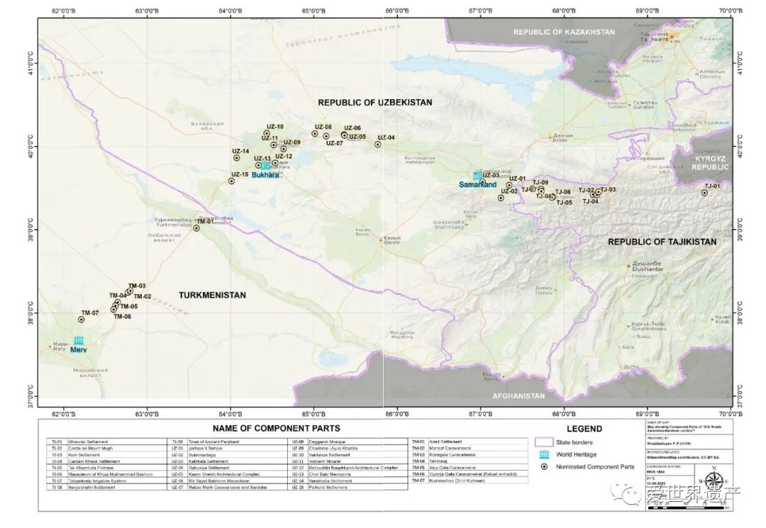
泽拉夫尚-卡拉库姆廊道是丝绸之路在中亚的关键路段之一,它连接着来自四面八方的其他廊道。本项目共有34个遗产点,分布在崇山峻岭、肥沃的河谷和荒无人烟的沙漠中,全长866公里,自东向西沿泽拉夫尚河延伸,再向西南沿着穿越卡拉库姆沙漠的古代商队道路到达绿洲城市梅尔夫(土库曼斯坦的世界遗产古梅尔夫国家历史文化公园)。在公元前2世纪至公元16世纪丝绸之路的历史时期,该廊道经历了3个繁荣时期:5-8世纪粟特商人的崛起;10-12世纪与穆斯林世界及其他地区的繁荣贸易;13-17世纪蒙古人统治时期科学、文化、城市规划和经济的重大发展。
Draft Decision: 45 COM 8B.13
The World Heritage Committee,
1. Having examined Documents WHC/23/45.COM/8B and WHC/23/45.COM/INF.8B1,
2. Inscribes the Silk Roads: Zarafshan-Karakum Corridor, Tajikistan, Turkmenistan, and Uzbekistan, on the World Heritage List on the basis of criteria (ii), (iii) and (v);
3. Adopts the following Statement of Outstanding Universal Value:
Brief synthesis
The Zarafshan-Karakum Corridor is one of the key sections of the Silk Roads in Central Asia that connects other corridors from all directions. Comprising thirty-four component parts located in rugged mountains, fertile river valleys, and uninhabited desert, the 866-kilometre corridor runs from east to west along the Zarafshan River and further southwest following the ancient caravan roads crossing the Karakum Desert to the Merv Oasis.
Nominations to the World Heritage List WHC/23/45.COM/8B, p.31
Dotted along the corridor passing through varied geographical areas such as highland, piedmont, dry steppe, oases, fertile valleys, and arid-desert zones, the selected component parts reflect the complexity of landscapes and the adaption of societies to the control of the Silk Roads movement and trade. The variation in human responses between the fertile valleys and deltas, and the desert and river crossings, are clearly reflected in the selection of small towns, forts, and way stations; while the outcomes of the political and social capital generated by trading contacts are reflected in the range of commercial, elite, and religious buildings included in the nomination. It was the place where the Sogdians, some of the most international merchants in the world history, flourished. The control of these corridors was of vital significance to many of the great Silk Roads empires, such as the Sogdian, the Parthian, the Sassanian, the Timurid and the Seljuk, as they were fundamental to long-distance exchange along the Silk Roads.
Along the corridor, a large quantity of goods and some high-value commodities from the East and the West were moved and traded, and many famous local products were brought out of there to feed the desires of the populations afar. People travelled, settled, conquered, or were defeated there, making it a melting pot of ethnicities, cultures, religions, sciences, and technologies. During the historic period of the Silk Roads between the 2nd century BCE and the 16th century CE, the Corridor had experienced three prosperous periods: the rise of Sogdians merchants between the 5th and 8th centuries CE; the thriving trade with the Muslim world and beyond between the 10th and 12th centuries CE, and significant development of science, culture, urban planning and economics under the Mongols' rule from the 13th century to the 17th century CE.
Criterion (ii): The Zarafshan-Karakum Corridor exhibits an important interchange of human values over a span of eighteen centuries in the heart of Central Asia as demonstrated by the architecture, monuments, town planning, landscapes, arts, and technology of its component parts which reflect diversified cultures, ethnic traditions, beliefs, and technologies in both distinct and fused ways. Being one of the key sections at the centre of the Silk Roads network linking multiple ethnic regions, which has been alternatively controlled by nearby great empires, the Zarafshan-Karakum Corridor clearly demonstrates the diversity of populations, and the cultures and traditions, ideas and beliefs, as well as knowledge and technologies associated with them.
Criterion (iii): The territory of the Zarafshan-Karakum Corridor is overlaid by rich layers of cultural depositions which accumulated throughout history, which is an exceptional testimony to the cultural traditions of the societies that were shaped by the trade and exchanged along the Corridor. These are evidenced by the wealth of the Sogdian merchants as displayed by their luxurious residences, the Sogdian temples with fire altar and murals, the Achaemenid citadels, the early Islamic hypostyle mosques with a large minaret, the rich Sufism buildings after the Great Arab Conquest, the advanced irrigation systems, as well as the wide spectrum of the caravan service facilities that had been provided and maintained by the successive empires controlling the Corridor.
Criterion (v): The Zarafshan-Karakum Corridor is an outstanding example of traditional human settlements and land use that is representative of human interaction with nature. The territory of the Corridor covers diverse geographic areas such as highlands, piedmonts, dry steppes, oases and fertile valleys, and arid-desert zones, which dictated the town planning, architectural designs, agricultural and other production activities. It was also the people’s determination, initiatives, and ingenious designs that transformed the harsh land into one on which populations thrived.
Integrity
The integrity of the property is at two levels: the corridor level and the individual component part level. At the corridor level, the diversity of forms and functions of the selected component parts, including mausoleums, sardobas, caravanserais, minarets, mosques, religious complexes, settlements, and remains of ancient cities, fully demonstrate the active role the Corridor once played in history as a nodal section, which not only linked other corridors but also contributed to the trade with locally produced goods. The serial property as a whole also showcases the exchange of ideas and knowledge along the Silk Roads as the result of the movement of people and goods. At the individual component part level, all the attributes that are needed to convey the Outstanding Universal Value of the property are included in the property. The factors affecting the property, such as development pressure, are largely under the control of the States Parties.
Authenticity
The authenticity of the property resides at both the corridor level and the individual component part level. At the corridor level, the direction of the route, the geographical conditions, and the landscape settings that had shaped this section remain relatively unchanged over time. At the component part level, the location, the planning, and the layout of the sites remain unchanged. With many stretches of roads still used for transportation as they were used in the past, and most of the religious buildings and cemeteries still performing their original functions today. Many archaeological sites have been excavated and backfilled to protect the materials from deterioration, with the great majority of the portion remaining untouched, providing an opportunity for future research and the recovery of authentic data. The original materials and designs are found in most of the buildings. Conservation interventions conducted on the buildings observed internationally accepted principles such as minimal interventions. Reconstruction for interpretation purposes was undertaken in such a way that the reconstructed parts are distinguishable from the original structures and materials.
Management and protection requirements
The legal protection operates at the international, national, and component part levels. At the international level, an Agreement between the Ministry of Culture of the Republic of Tajikistan, the Ministry of Culture of the Republic of Uzbekistan and the Ministry of Culture of Turkmenistan for common promotion, management and protection of the components of the Serial Transnational Nomination “Silk Roads: Zeravshan-Karakum Corridor” was signed among the States Parties in 2020 as the legal basis for the protection and management of the property. At the national level, all thirty-four component parts are state-owned and listed under state-level legal designations. At the site level, all thirty-four component parts have been meticulously surveyed, studied, and documented, the necessary measures required for their preservation are implemented, and land-use restrictions as well as planning regulations necessary for conservation purposes, are put into effect.
The Zarafshan-Karakum Corridor is managed at the transnational, national, and component part levels. At the corridor level, the management is regulated by the Agreement, which establishes a Coordinating Committee and a Working Group for the overall protection and management of the property. The Coordinating Committee conducts meetings with relevant stakeholders to resolve arising issues on the protection and management of the Corridor. The Coordinating Committee, together with the local authorities also provides the necessary tools and training to the managers and inspectors and encourage research and joint activities for the protection and promotion of the Silk Roads Corridor. The Working Group conducts meetings to discuss issues on protection and management of the component parts at the request of the Coordinating Committee. The Working Group is also responsible for the monitoring of the state of conservation of the component parts and informing the Coordinating Committee on adopted decisions. The International Institute for Central Asian Studies (IICAS), based in Samarkand (Uzbekistan), facilitates the sharing of information among the countries during management processes. It also acts as the secretariat of the nomination of the Zarafshan-Karakum Corridor.
At the national level, all the component parts are owned by the States Parties, and designated as protected heritage sites. Ministries of Culture of the States Parties are respectively responsible for the management of the cultural heritage in their countries in terms of state registration, policy-making, administration and budget allocation, among others.
At the component part level, each site is managed by the regional branches or governmental institutions under the Ministries of Culture of the States Parties. The costs of site management, maintenance, conservation, and monitoring are mainly covered by the central and local government annual budgetary fund, while national and international ex-budgetary aids are allocated for specific projects such as conservation campaigns, capacity building, and research. Technical support is provided by international resources, as well as universities, and academic institutions of the States Parties.
Staff capacity has been significantly improved in the past decade, but can be further strengthened in the future. A site management plan with a monitoring mechanism should be developed for each component part, and an interpretation strategy should be adopted.
4. Recommends that the States Parties give consideration to the following:
a) Developing and implementing a five-year management plan with monitoring mechanisms as an integral part,
b) Developing and implementing a coordinated interpretation strategy to guide all the interpretation initiatives at the component parts,
c) Establishing visitor management systems at all component parts with basic infrastructure, safety measures, service, and interpretation,
d) Continuing capacity building for on-site staff members,
e) Undertaking research to address the problem of rising damp coupled with salt activities that damage the lower portion of historic structures of the component parts,
f) Engaging local communities in site management, archaeological excavation, conservation and restoration, and tourist services for them to better benefit from the World Heritage status,
g) Undertaking research on artificial irrigation systems that helped the growth of the populations and cities in the region, with the view to consider potential extensions of the property in the future,
h) Considering the Sheibanikhan Water Divider Bridge in the future as an extension of the property when conditions allow it,
i) Investigating on the location and extent of the Toksankoriz Irrigation System (Tajikistan) component part and adjusting the boundaries of the property area and the relevant buffer zone accordingly, so as to cover the whole historical irrigation system, through a minor boundary modification request,
j) Undertaking a study on the associative values of the necropolis, the pilgrim route, and the sacred spring outside the buffer zone of the Mausoleum of Khoja Mukhammad Bashoro (Tajikistan) component part, taking into consideration the requirements of integrity and authenticity, and considering adjustments of the boundaries of this component part, through a minor boundary modification request, if relevant,
k) Incorporating the three World Heritage properties along the Corridor into the management and interpretation systems of this property;
5. Requests the States Parties to submit to the World Heritage Centre by 1 December 2024, a report on the implementation of the above-mentioned recommendations for examination by the World Heritage Committee at its 47th session.